| Lebanese Republic |
|
|


|
|
 |
|
|
ICAO letter concerning the risks of Laser lights

The hazard posed by laser attacks against civil aircraft, specifically the deliberate targeting of flight crew with laser illumination to disrupt the safe operation of the aircraft, is a matter of increasing concern. Available data indicate that the frequency of laser attacks on civil aircraft has risen significantly..
Laser attacks targeting flight crews can result in distraction, disruption, disorientation and, in extreme cases, incapacitation, adversely affecting the ability of the flight crew to carry out their responsibilities, especially during take-off and landing. Therefore, directing laser illumination at an aircraft may be construed as intentional interference with a flight crew member’s on-board duties..
In consideration of the increasing rate of laser attacks globally and their potentially catastrophic consequences, I urge you to highlight this issue as a hazard to civil aviation, and to ensure the general public is fully aware of the seriousness and possible consequences of these attacks. I also strongly encourage your State to enforce all relevant laws and to apply penalties against perpetrators in accordance with applicable legislation. Should current legislation not cover laser attacks, I urge your State to consider including legal provisions to address the issue of laser attacks against civil aircraft, and to penalize such attacks..
(Ref: letter/ AS8/5-14/83).
Jeita the jewel of Lebanese tourism
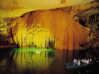
Jeita Grotto represents the master piece of Lebanese nature. It is also considered the jewel of Lebanese tourism.
It is located 20 km north of Beirut in the valley of Nahr-al-kalb. In this cave the action of water in the lime stone has created cathedral – like of various sizes, colors, and shapes of stalactites, and stalagmites, majestic curtains and fantastic rock formations.
The total length of the cave is 9040m. The grotto is made up of two lime stone caves: upper galleries which are about 2130m long, and a lower cave through which 6910m long river runs.
Geologically, the caves provide a tunnel for both the wet and dry parts which extends up to 11 km.
In 1958, Lebanese speleologists discovered the upper galleries, while the lower cave was discovered in the 19th century which has been accommodated with an access tunnel and a series of walk ways to enable tourist’s safe access by a small train or by the Telefric above the alley of the Nahr-al-kalb in the heart of green mountains.
In the lower caves, the first impression is the sound of rushing water and a sensation of clean cold. But the roar of the water fall at the entrance gives way to profound silence. As you glide deeper into the cave, whether right or left, an effective new lighting system illuminates expert rock-climbers and marvel at the columns and sculptures fashioned by those grate architects-water and time when visitors are transported by boats.
In Brief, Jeita Grotto is a popular re-creational show cave and a major tourist attraction. It was a candidate for the new 7 wonders of nature competition.
70th anniversary of the Chicago convention
![]()
On the fifth of December 2014, at the organization's headquarters in Montreal, the International Civil Aviation Organization (ICAO) will be celebrating, the 70th anniversary for signing the Convention on International Civil Aviation, otherwise known as the Chicago Convention.
The secretary General of the ICAO, Mr. Raymond Benjamin, has invited all member states to attend and participate to this annual event.
Let us recall that, in 1944, at the invitation of the United States of America, the International Conference on Civil Aviation was held at the Grand Ballroom of the Stevens Hotel in Chicago, and delegates from 54 nations were convened. The conference led to concluding and signing the Convention on International Civil Aviation, which was considered as the defining international agreement that has permitted the international civil aviation network to develop.
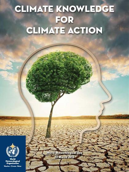
Climate knowledge for climate action.
Weather forecasts have been a part of everyday life since the mid twentieth century. Before going to work or school, people check the weather in order to know how to dress and how to keep safe. Weather forecasts help farmers, emergency workers and other decision makers in weather-sensitive sectors to schedule their daily and weekly work priorities. These forecasts are becoming ever more reliable – today’s five-day weather forecast is as good as the two-day forecast of 25 years ago – thanks to advances in weather and climate science and in computing power.
Researchers are using improved observations and greater computing power to study and predict natural cycles and broader patterns in the climate system. As a result, they can provide increasingly useful seasonal climate predictions. For example, they can assess the probability that the next season will be hotter or wetter than usual. Weather and climate predictions for the next month, the coming monsoon or growing season, or the next El Niño/Southern Oscillation event will become more and more reliable and useful over the coming years.
In addition to greater knowledge about natural climate variability, scientists have made enormous progress in understanding how humanity’s greenhouse gas emissions are changing the climate. Drawing on climate science and scenarios of greenhouse gas concentrations, they can project how the climate will change, and they can assess vulnerabilities and likely impacts in specific regions. This knowledge is invaluable for longer-term planning.
Delivering and using knowledge
While the science progresses every year, a great deal is also being learned about how to help decision makers understand and apply climate knowledge. This enables the providers of weather and climate knowledge to develop and offer customized information for a wide range of users. They are building partnerships with decision makers and communities to develop and deliver reports, graphics and other information products that these users can understand and use as a basis for action. Each user has different needs for particular types of climate knowledge and the language, frequency and format in which it is delivered.
For example, public health authorities may want to use forecasts of how the intensity and frequency of droughts, heatwaves and floods will evolve in the coming months and years to ensure that medical services and supplies are available where and when needed. They may be concerned that lower-than-average rainfall will increase the risk of nutritional and respiratory problems, while above-average rainfall may lead to outbreaks of vector-borne diseases such as malaria or waterborne diseases such as cholera.
Weather and climate information can be integrated with maps showing population densities and the location of hospitals and transport systems to support the timely roll-out of vaccines ahead of a disease outbreak. In the longer term, knowledge about the anticipated intensity and frequency of droughts, heatwaves and floods can be used to shape the planning of medical and emergency services.
Until recently, interaction between the health and climate communities was rare. That is changing. The World Meteorological Organization and the World Health Organization are working together to bridge the gap and ensure that climate information is mainstreamed into health planning at both the international and national levels. Training workshops in countries such as the United Republic of Tanzania and Malawi are helping health professionals interpret and use meteorological data to improve public health.
Climate knowledge is benefiting many other climate-sensitive sectors as well. Farmers are using information and predictions about temperature trends and the onset of the rains to decide well in advance what crops to plant and when to irrigate or harvest. For agricultural policymakers, a monsoon forecast plus information on past cropping decisions and market trends can support decisions on food security. Meanwhile, water managers analyse climate information in order to estimate available water supplies and the need for new infrastructure. And so on.
The future of decision making
Traditional weather reports offer valuable tactical information, but climate knowledge can be used to guide strategies and long-term plans for building climate resilience, reducing disaster risks and managing the farming, health, transport, energy, water and other vital systems that we all depend on. This revolution in climate knowledge is just beginning. In five to 10 years people will become just as familiar with using climate predictions as they are with weather forecasts.
Imagine it is 2025 and you are a city planner responsible for ensuring that your community is resilient in the face of changing climate conditions. You must develop plans for building codes, water management, sewage, traffic and emergency preparedness that will remain effective for decades to come. Fortunately, you now have access to good-quality, credible scientific predictions and information on how seasonal and even multi-year variations in the climate may affect averages and extremes in temperatures, precipitation and wind – fine-tuned for your region. You can combine this climate information with maps and data on demography, economics, land-use change, topography, medical infrastructure, hydrology and more to inform the specific actions you need to take.
In addition, you may wish to explore climate change scenarios in order to assess potential risks and vulnerabilities in future decades. By integrating long-term climate projections directly into impact assessments, you can estimate the risk that future storms will cause power outages (for example, by combining data on climate conditions with information on patterns of energy use), or you can assess how a long-term trend towards more droughts or floods will affect energy resources and infrastructure requirements. You may also use this knowledge to take action on reducing greenhouse gas emissions, for example, by rationalizing energy consumption through the optimal timing of renewables production and allocating resources more precisely for agriculture, construction and transport.
Empowered by weather and climate knowledge, decision makers will have increasing confidence in their ability to take effective climate action. They will further reduce the risks of disasters caused by climate variability through integrated assessments of vulnerabilities, potential impacts and early warning systems. They will predict and respond more effectively to climate fluctuations that affect food security, public health, water resources and other climate-sensitive sectors. They will also use climate-change scenarios based on increasingly robust and high-resolution models to build climate resilience, address the particular vulnerabilities of women and children, and make decisions on land use, coastal management, and roads and other infrastructure. The benefits of an informed response to climate variability and change are huge: lives saved, livelihoods protected, property secured, negative impacts minimized and opportunities maximized.
Today we have more weather and climate knowledge than ever before. Ignorance is no longer an excuse for not taking steps to minimize climate risks. Effective climate action can ensure human well-being today and through the rest of the twenty-first century.

Global Framework for Climate Services
The Global Framework for Climate Services (GFCS) is building a solid climate knowledge base for climate action at both country and community level. Spearheaded by the World Meteorological Organization, the GFCS is an international partnership for strengthening the provision of reliable, science-based climate services to support sustainable development and build climate resilience.
The challenges of weather extremes and climate change transcend national boundaries. The GFCS promotes international collaboration, the pooling of resources and the sharing of best practices in order to build capacity, especially in the 70 developing countries that lack the resources and expertise they need for their citizens to benefit from climate services.
The GFCS provides a platform for dialogue between national weather services and other knowledge providers on the one side, and policymakers and other users of weather and climate knowledge on the other. This ensures that climate services are relevant and accessible, especially to users in priority climate-sensitive sectors such as agriculture, water management, public health, energy and disaster risk reduction.
(This report has been published by: WMO)